Streetly in history

The district of Streetly takes its name from the Ryknield Street, a Roman road, the line of which can still be followed in Sutton Park starting at the Parson & Clerk Inn and running for about two miles towards the railway line. There is archaeological evidence of Stone Age people in the area. The earliest written record of the name Streetly is found in an Anglo-Saxon Charter dated 959 when an estate at Great Barr and Easton (Little Aston) was granted to thegn Wulfhelm.
In medieval times the district was still largely forest and formed part of the Earl of Warwick's Chase of Sutton with a Manor House on Manor Hill in Sutton Coldfield.
By the 13th century charcoal burners had cleared much of the original forest, hence the name 'The Colefield'. The land was left as heath and marshland which was described in the late 18th century as "a barren sheep walk containing in some large tracts scarcely any other plants than heath, in other places fern, gorse, whortleberries and rushes with grass in small proportion". Much of the area which then formed part of Great Barr Common was enclosed in 1795 at the behest of local landowners including Sir Joseph Scott of the Nether Hall, Great Barr, and Mrs. E Foley of Great Barr Hall. The land so enclosed was divided and let as 9 farms.
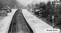
In 1879 the Midland Railway Company opened a station at the corner of Foley Road and Thornhill Road and gave it the name of Streetly Station. Development of the district started in Streetly Lane and Foley Road and the adjacent land, all within easy reach of the railway station which formed the main access to the area for most people until well into the 20th century. The station was closed in 1965. Until 1914 housing development was limited to the area between Thornhill Road and the Chester Road. A church was built in Foley Road in 1908 to serve as a chapel of ease to Great Barr Parish Church and a school was opened in Foley Road in 1908.
Between 1918, when Mr. Arthur Turner's estate at Streetly was sold and divided amongst the original 9 farms, and 1939, housing development continued in the same area. Blackwood Road was cut through farm land in the 1920's. However much of the area remained relatively rural in character until after 1945.

The present amenities such as the Methodist Chapel in Blackwood Road, St. Anne's Roman Catholic Church, the Clinic and the Library in Blackwood Road date from the period 1960-1970 as does much of the housing stock which is privately owned.
Whilst still retaining much open space, a once sparsely populated rural area has grown today into a residential suburb of some 21,000 inhabitants. Access to all parts of the Midlands and the rest of the country has been simplified with the availability of modern transport and access to the M6 motorway at Great Barr.
C. R. Robertson