Rushall in history
The first record of Rushall occurs in Domesday Book (1086) where its total annual value to its lord was assessed as 10 shillings. This was from a village of eight households and a mill. The name means 'a place in marshy ground where rushes grow' and the early settlement by the Saxons probably occurred to the north of Rushall Hall, where there are remains of a moated site. Nineteenth century excavations found Saxon coins in earthworks in that area.
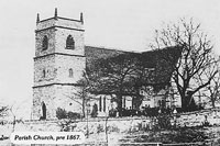
The feudal lordship did not originally have its own parish church as the first mention of the church in 1220 describes it as a chapel of Walsall. However the lords of Rushall were always independent and they secured the chapel's parish status. In 1440 John Harpur rebuilt Rushall Church on the chapel-site next to his Hall. It survived the Civil War to be rebuilt 1854-6. The old square tower remained until 1867.
Rushall Hall today is substantially a 19th century structure, incorporating walls from the earlier building. At the time that the massive, still surviving, fortified gatehouse and walls were built in the 13th and 14th centuries the house itself was probably made of timber. The Leigh family succeeded to the Harpurs in the middle of the 16th century and took a leading part in county politics. At the start of the Civil War in 1642, Edward Leigh was an MP and an opponent of the King. He fortified the Hall and joined the army as a colonel. His wife, left in command at Rushall, could not hold the Hall against the forces of Prince Rupert in 1643. The royalists in their turn were ejected after a short siege in 1644. During the 18th century the Leighs became absentees as were their successors, the Mellish and Buchanan families. The estate was finally sold off in 1945.
Limestone of high quality lies near the surface at Rushall. It was exploited by the Romans and through the Middle Ages for building and agricultural purposes. The use of limestone as flux for smelting iron caused great expansion in mining during the Industrial Revolution. A new settlement grew up at Daw End, and the Hay Head and Linley workings were both on a large scale. The quarries in Rushall Hall's park flooded to become the Park Lime Pits - today a nature reserve. The Arboretum lakes, then also in Rushall, were similarly formed by quarrying.
In the south west corner of the parish the areas of Butts and Ryecroft rapidly developed as suburbs of Walsall from the middle of the 19th century. The main settlement at Rushall was established on the Lichfield Road at the junction of Pelsall Lane, Daw End Lane and Coalpool Lane (Station Road) where a toll bar was set up after the main road was turnpiked in 1766.
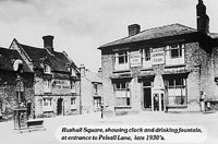
At the start of the twentieth century Rushall was a thriving village set round the Square. It was served by Anglican, Methodist and Congregational chapels and had its own Police Station and Court. Since 1945 Rushall Square has lost much of its character to road improvements. New housing developments, particularly around Barns Lane, have increased the population.
Walsall Local History Centre